Airborne gravity
Return to WISE-ISODYN Data Index Page
Airborne gravity are presented in (Jordan et al., 2013). Further details on data collection are presented in (Jordan et al., 2007). The dataset available here includes all channels from raw through to filtered and upward continued free air anomalies. All data is provided in the ‘by flight’ database. Only line sections with usable data are presented in the line by line database. Data processing steps are below, and the full definition of all channels is in the table. Note in version 1 (V1) only data from the main high resolution grid are available.
Download Data
Download airborne gravity data by flight
Download Geosoft database(174 MB) Download Ascii (47 MB)
Download airborne gravity data by line
Download Geosoft database(100 MB) Download Ascii (33 MB)
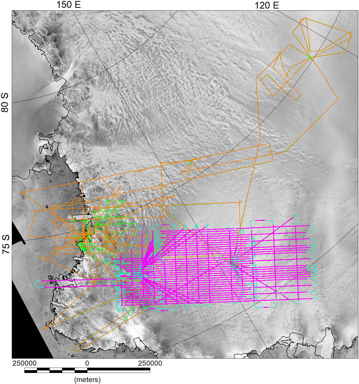
Gravity data distribution. Pink lines show high quality gravity data available in release V1. Pale blue lines mark full flight line gravity data available in release V1. Orange lines show full raw-gravity data coverage. Green lines mark flights with no gravity data.
Raw data from L&R meter #S83 includes:
Channel names in bracketsSpring tension (ST) meter units
Cross coupling (CC) meter units
Raw beam position (RB) mV
Cross axis accelerometer output (XACC) mV
Long Axis accelerometer output (LACC) mV
Gravity processing steps were as follows:
1/ Calculate observed gravity.
True spring tension (ST_real) is calculated from the posted spring tension (ST) correcting for the fact that for this survey the true spring tension approaches the posted value at 40 mGal per second.
Beam velocity (Beam_vel) is derived from raw beam position (RB) assuming a centred difference approximation.
Relative gravity (rec_grav) = ((ST_real+CC)*0.9966)+(Beam_velocity*k_fac), k_fac=60/2.04, meter scale value =0.9966.
Still readings are in mGal (Still), and were calculated assuming a linear best fit to the drift of the airborne meter observed at base stations at Mario Zucchelli, Talos Dome, Dome C, and C3 (Jordan et al., 2007). Tie absolute gravity values for the survey (Base) were derived from land gravity measurements adjacent to the survey aircraft (Jordan et al., 2007).
Airborne absolute gravity values (Abs_grav) = Rec_grav – Still + Base
2/ Corrections to derive free air anomalies (disturbances).
Vertical acceleration (VaccCor) is calculated as 2nd derivative of flight altitude (Height_WGS1984)
Eotvos correction (EotvosCor) follows (Harlan, 1968).
Latitude correction (LatCor) = 978.03185(1+0.005278895 sin2Lat – 0.000023462 sin4Lat) (IUGG 1967).
Free air correction (FaCor) = 0.3086*Height_WGS1984. NOTE subsequent free air values are defined as gravity disturbances in geodesy, as they are referred to the ellipsoid (Hackney and Featherstone, 2003).
Horizontal acceleration correction (HaccCor). For this survey the approximation of (Swain, 1996) was used, assuming a damping factor of 0.707, and a platform period of 4 minutes.
3/ Free air anomaly and filtering.
Free air anomaly (Free_air) = Abs_grav-VaccCor+EotvosCor+FaCor-LatCor-(0.5*HaccCor)
Filtered free air anomaly (FAA_filt) used 9 km 1/2 wavelength space domain kernel filter (Holt et al., 2006).
Final free air data (FAA_clip) was produced by manually masking turns, start and end of lines, and other regions of noisy data.
Upward continued free air anomaly (FAA_3750m) was produced by upward continuing each line segment from the collected flight altitude to 3750 m, the highest altitude in the survey.
Note no levelling has been applied to the free air gravity data.
| Basic Channels | ||
|---|---|---|
| Date | UTC date (YYYY/MM/DD) | |
| Time | UTC time (HH:MM:SS.SS) | |
| FlightID | Sequential flight number and survey ID e.g. W12 | |
| Line_name | Line Number e.g. LW200.1:12 | |
| Lon | Longitude WGS 1984, for processing see readme | |
| Lat | Latitude WGS 1984, for processing see readme | |
| x | x projected meters, coordinate system defined in readme | |
| y | y projected meters, coordinate system, defined in readme | |
| Height_WGS1984 | Aircraft altitude (meters) in WGS 1984, for processing see location data page |
| Raw gravity Channels | ||
|---|---|---|
| ST | Spring Tension (meter units) | |
| CC | Cross Coupling (meter units) | |
| RB | Raw beam position (Mv) | |
| XACC | Cross axis accelerometer (Mv) | |
| LACC | Long axis accelerometer (Mv) | |
| Still | Airborne meter still reading value (mGal) | |
| Base | Absolute gravity reference, from land gravity (mGal) |
| Calculation Channels | ||
|---|---|---|
| St_real | True Spring tension value (meter units) | |
| Beam_vel | Gravity meter beam velocity (Mv/sec) | |
| Rec_grav | Recalculated relative gravity (mGal) | |
| Abs_grav | Calculated absolute gravity (mGal) | |
| VaccCor | Vertical acceleration correction | |
| EotvosCor | Eotvos correction | |
| LatCor | Latitude correction | |
| FaCor | Free air correction | |
| HaccCor | Horizontal acceleration correction |
| Free air Channels | ||
|---|---|---|
| Free_air | Un-filtered free air anomaly | |
| FAA_filt | Filtered free air anomaly | |
| FAA_clip | Filtered free air anomaly masked | |
| FAA_3750m | Upward continued free air anomaly to altitude 3750 |
References
Hackney, R.I. & Featherstone, W.E., 2003. Geodetic versus geophysical perspectives of the gravity anomaly, Geophys. J. Int., 154, 35-43.
Holt, J.W., Richter, T.G., Kempf, S.D. & Morse, D.L., 2006. Airborne gravity over Lake Vostok and adjacent highlands of East Antarctica, Geochem. Geophys. Geosyst., 7, doi:10.1029/2005GC001177.
Jordan, T.A., Ferraccioli, F., Armadillo, E. & Bozzo, E., 2013. Crustal architecture of the Wilkes Subglacial Basin in East Antarctica, as revealed from airborne gravity data, Tectonophysics, 585, 196-206.
Jordan, T.A., Ferraccioli, F., Corr, H., Robinson, C., Caneva, G., Armadillo, A., Bozzo, E. & Frearson, N., 2007. Linking the Wilkes Subglacial Basin, the Transantarctic Mountains, and the Ross Sea with a new airborne gravity survey. in The Italian–British Antarctic Geophysical and Geological Survey in Northern Victoria Land 2005–06—Towards the International Polar Year 2007–08, pp. 37-54, eds. Bozzo, E. & Ferraccioli, F. Terra Antartica Reports.